

INTRODUCTION:
The Global Positioning System (GPS) is a U.S. space-based global navigation satellite system. It provides reliable positioning, navigation, and timing services to worldwide users on a continuous basis in all weather, day and night, anywhere on or near the Earth.
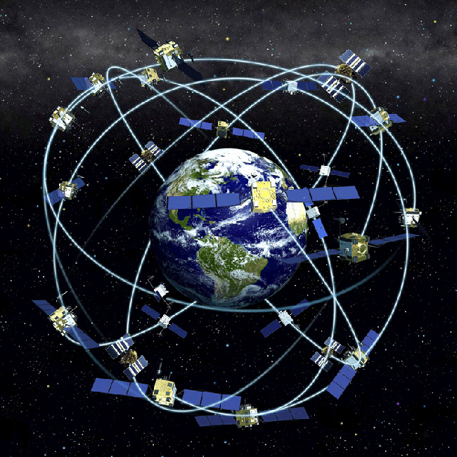
GPS is made up of three parts: between 24 and 32 satellites orbiting the Earth, four control and monitoring stations on Earth, and the GPS receiversowned by users. GPS satellites broadcast signals from space that are used by GPS receivers to provide three-dimensional location (latitude, longitude, and altitude) plus the time.
Since it became fully operational on April 27, 1995, GPS has become a widely used aid to navigation worldwide, and a useful tool for map-making, land surveying, commerce, scientific uses, tracking and surveillance, and hobbies such as geocaching and waymarking. Also, the precise time reference is used in many applications including the scientific study of earthquakes and as a time synchronization source for cellular network protocols.
GPS has become a mainstay of transportation systems worldwide, providing navigation for aviation, ground, and maritime operations. Disaster relief and emergency services depend upon GPS for location and timing capabilities in their life-saving missions. Everyday activities such as banking, mobile phone operations, and even the control of power grids, are facilitated by the accurate timing provided by GPS. Farmers, surveyors, geologists and countless others perform their work more efficiently, safely, economically, and accurately using the free and open GPS signals.
HISTORY OF GPS:
The first satellite navigation system, Transit, used by the United States Navy, was first successfully tested in 1960. It used a constellation of five satellites and could provide a navigational fix approximately once per hour. In 1967, the U.S. Navy developed the Timation satellite which proved the ability to place accurate clocks in space, a technology that GPS relies upon. In the 1970s, the ground-based Omega Navigation System, based on phase comparison of signal transmission from pairs of stations, became the first worldwide radio navigation system.Friedwardt Winterberg [1] proposed a test of General Relativity using accurate atomic clocks placed in orbit in artificial satellites. To achieve accuracy requirements, GPS uses principles of general relativity to correct the satellites' atomic clocks. The design of GPS is based partly on similar ground-based radio navigation systems, such as LORAN and the Decca Navigator developed in the early 1940s, and used during World War II. Additional inspiration for the GPS came when the Soviet Union launched the first man-made satellite, Sputnik in 1957. A team of U.S. scientists led by Dr. Richard B. Kershner were monitoring Sputnik's radio transmissions. They discovered that, because of the Doppler effect, the frequency of the signal being transmitted by Sputnik was higher as the satellite approached, and lower as it continued away from them. They realized that since they knew their exact location on the globe, they could pinpoint where the satellite was along its orbit by measuring the Doppler distortion (see Transit (satellite)). After Korean Air Lines Flight 007 was shot down in 1983 after straying into the USSR's prohibited airspace,[2] President Ronald Reagan issued a directive making GPS freely available for civilian use, once it was sufficiently developed, as a common good.[3] The first satellite was launched in 1989 and the 24th and last satellite was launched in 1994. Initially the highest quality signal was reserved for military use, and the signal available for civilian use intentionally degraded ("Selective Availability", SA). Selective Availability was ended in 2000, improving the precision of civilian GPS from about 100m to about 20m.